
Pixel-perfect precision: Why not all drone maps are created equal for AI analysis
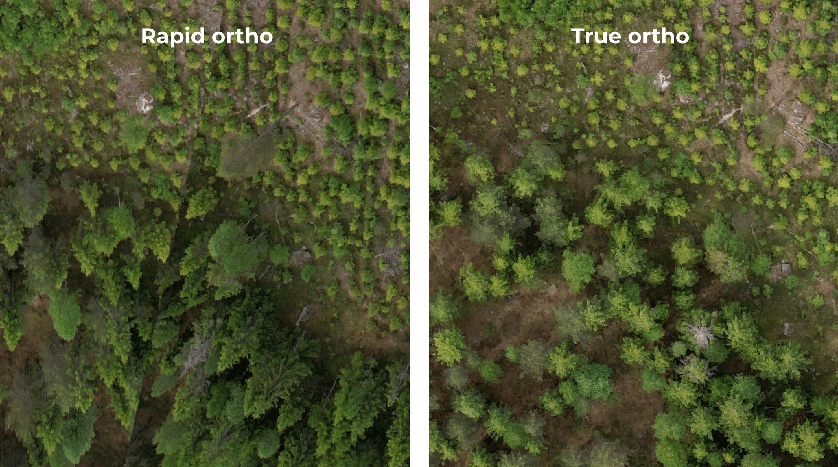
At Arboair we use the full spectrum of aerial imagery, including data from aircraft and satellites, to offer flexible and scalable solutions. High-resolution drone imagery does, however, offer a unique combination of detail and flexibility that is particularly powerful. But even with drones, the technique used to stitch thousands of individual photos into a single map — an orthophoto — can lead to widely differing results. Let us explore the two primary methods we use: "Rapid Ortho" and "True Ortho".
The need for speed and scalability: Introducing Rapid Ortho
Imagine you need to assess a vast forest quickly for storm damage or spruce bark beetle attack. Your priority is not a beautiful map for a brochure, but razor-sharp analytical clarity across a massive area, delivered fast and cost-effectively. This is the perfect scenario for our Rapid Ortho method.
Our Rapid Ortho is generated with Arboair's proprietary image-stitching algorithm and is purpose-built for AI analysis. Our algorithm is designed to produce the sharpest possible images of individual trees, which is decisive for our analysis models. By optimising for analytical quality we can fly with less image overlap, allowing us to cover areas up to ten times faster than conventional mapping flights. This translates directly into significant time and cost savings for our customers. The resulting map is a purely functional tool; while it may not be entirely seamless from a visual perspective and may have a GPS error of a few metres, the clarity of every tree is unmatched. Think of it as a raw, functional blueprint — every crucial detail is crystal clear, enabling precise and reliable analysis across vast landscapes.
The perfect map image: Introducing True Ortho
Now imagine a different situation. You might be an urban planner developing a detailed, public plan for a new park, or an arborist who needs an accurate elevation model to assess risk near infrastructure. Here, visual impression and absolute positional accuracy are what matter. For this we use the True Ortho method.
We create True Orthos using the latest photogrammetry software, such as DJI Terra. This process carefully corrects for perspective distortion and differences in elevation, resulting in a visually striking and geographically accurate map that looks like a single, seamless photograph taken straight from above. A significant advantage of this method is the creation of highly accurate, up-to-date digital elevation models (DEM) and surface models (DSM), which are invaluable for many planning applications. This beauty comes at a price, however. The process is slower, covers smaller areas, and the very act of creating a visually perfect image can sometimes introduce subtle artefacts — smeared or distorted tree crowns — that can slightly degrade the quality of an AI-driven analysis. While it is an incredibly valuable tool, its focus is on visual and positional perfection rather than the pure, unadulterated clarity required for the most demanding AI analysis.
The right tool for the right job
So why does this distinction matter so much? Because our AI models thrive on clarity. A slightly distorted tree crown on a visually perfect True Ortho can be more confusing to an AI than a crystal-clear tree on a Rapid Ortho that sits a few metres from its absolute GPS position. For our system, the primary goal is to identify the tree's characteristics — its species, health and size.
Our philosophy is always to choose the right tool for the right job. We do not believe in one-size-fits-all. By understanding your unique goals we can tailor a data collection and analysis strategy that delivers the greatest value. If you need to analyse hundreds or thousands of hectares with maximum efficiency for forest health or inventory, Rapid Ortho is the clear winner. If your project requires a visually perfect map and a detailed elevation model for urban planning, True Ortho is the ideal solution.
This expertise in selecting and processing the right type of data is what allows Arboair to deliver on its promise: to provide the most precise, reliable and cost-effective tree data to drive sustainable and efficient management decisions.
Curious to know which imaging solution would suit your project best? Contact us today to start a conversation.